Ā
Ā
,
- Tuesday, April 16, 2024
Southern California Trails
- Socal(290)
- -> Los Angeles County(114)
- -> Wrightwood(2)
- -> Manzanita
Manzanita - #Manzanita
Socal - Los Angeles County - Wrightwood NickNames: #Manzanita
Drive west on Angeles Crest Highway (CA 2) about 9.5 miles from Wrightwood to Vincent Gulch Divide Thomas Guide page 4470
- All
- 14 Updates
- 0 Reviews
- 0 Routes
- 0 Conditions
- 0 Checking in -
- Last update
- Random
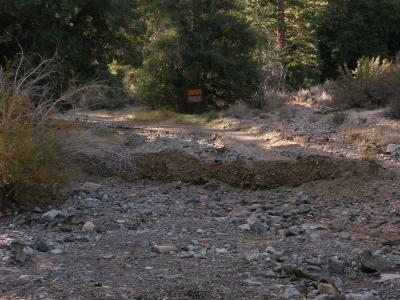
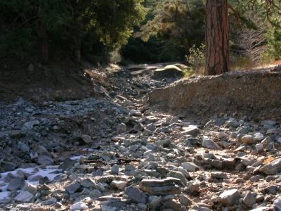
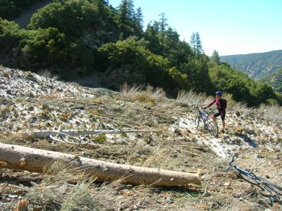
- Trail UpdateNot Much Trail Left-Indeed, as the previous post states, road 4N11 from the boys camp to Vincent Gap is open and in great shape. Alas, that is where the work to fix damage has stopped. The Manzanita (High Desert Trail) is a mess. Now I know that even in it best days this trail was always known for having loose sections and lots of rocks in the trail. Add into the mix the acorns and this was a trail that you had to pay constant attention on. Well currently about 1/3 of the trail is still like that. And that part is quite enjoyable. It is the other 2/3rd that have changed, and not for the better. Much of the trail has been washed out and is not rideable no matter how good you are technically. Not fun at all in these sections. The other third is so loose you cannot ride on it as it slides away under your tires, mixed with scree that has consumed huge sections of what used to be the trail. As we walked through these sections the dirt immediately consumed our foot prints and there was no evidence that we had come through. Again no fun going through these sections. The last 1.5 miles into South Fork Campground are the best part of the trail and is quite fun.
This trail is no longer worth the drive. Until many man-hours are put into restoring the trail to previous (and those are not ideal) conditions I would not recommend riding here. Luckily we went to the area to ride the Blue Ridge D and had some energy left over so we did this as well, so the trip was not a complete waste. The Blue Ridge D by the way is in great condition and well worth the trip. And the trailhead is only a few miles from Vincent Gap. Head over there instead.
Matt a 38 year old Cross-Country Rider riding a Epiphany from Newbury ParkPosted:06/04/2007
- Trail UpdateBRC Road Repaired-The Big Rock Creek Road has been repaired between Camp Fenner and Vincent Gap. It's a bit soft due to fresh grading and lack of traffic, and will probably be that way until it opens in spring. However, they did screw up and failed to realign the road right where it is most vulnerable to flooding. No word on conditions on the Manzanita...my ride was truncated by a day-long blizzard.
Dr Wellington Yueh
Posted:12/19/2006
- Trail UpdateDeteriorating...-The conditions for Manzanita are deteriorating, and it appears that the USFS has permanently closed the Big Rock Creek Road between Camp Fenner and Vincent Gap (the 3 miles of dirt road). The road was never repaired after last spring's avalanches and flood damage, and has sustained further severe flood damage since then. The locked gate that used to be above the Big Rock Creek CG has been moved to the start of the dirt road at the Camp Fenner baseball field. The upper end of the dirt road at Vincent Gap has been blocked by huge dirt berms outside the gate. Not only does this complicate any potential vehicle shuttle, the road is so bad that walking is required for about 1/3 mile on the climb up to Vincent Gap.
The Manzanita Trail is also in pretty bad shape. Some of it is still very sweet, but there are enough damaged and neglected sections that now more walking is required than even before the USFS 'improved' the trail a few years back.
In short, this ride really isn't worth it anymore, unless you're prepared to walk a lot.
(CLICK ON IMAGES FOR FULL-SIZE VIEW)
Dr Wellington YuehPosted:12/22/2005
- Trail UpdateAVALANCHE!!!-
Bad!...but, seriously... Mostly it's great, only a few dead trees, the snow has probably melted out already.
Lazarus LongPosted:06/14/2005
- Trail UpdateUpdate?-Does anybody know the trail conditions? Planning to ride this trail some time next month. Thanks in advance for any help.
junebug0710 a 25 year old Die-hard Enthusiast riding a '05 Specialized Rockhopper from AlhambraPosted:06/14/2005
- Trail UpdateSome Snow Left-Rode east out of South Fork Campground this Saturday because I thought the warm winds of the last two weeks would have melted the snow off the top of the trail - WRONG. The uppermost 3/4 mile of the trail is six inches to a foot deep in snow, but the lower section was a nice ride. I saw two deep, old skids on the trail, one ending in a tree stump and the other continuing right off the trail. If you descend this trail without previewing it by riding UP it, be aware that many sections are loose gravel over a talus base, and traction is kinda iffy. Sections of the trail are invisible under pine cones and fallen branches, and you'll be pulling sticks out of your spokes a half-dozen times. Finally, the area is home to bears, and some of the big brown piles on the trail are neither rocks nor pine cones, and should NOT be ridden through. This is not a downhill run, but a rather isolated trail with no traffic noise, unlike the front-side trails. Delightful, in my opinion, but I'd advise waiting another two weeks before riding it to let most of the remaining snow melt away.
ScottR1Posted:01/27/2003
- Trail UpdateChanged Forever!-

Manzanita Trail and Angeles Crest Highway near Vincent Gap
Did the Manza on Saturday (4th Nov) and mostly had a good time, but recent storms and misguided humans have destroyed a fair portion of this once-excellent trail. Most of the upper section is the same as ever, except one of the smaller stream crossings has been completely wiped out by a large flash flood. By far the worst damage has been caused by misguided humans - the Forest Disservice has 'graded' the lower mile (above South Fork CG) with a Bobcat front-loader! The trail is now nearly a road, and all of the technical goodies have disappeared. The nice jumps on the smooth switchbacks have been dangerously 'accentuated' and can no longer be hit at speed. Many trees will probably die, as the blade of the beast sheared off literally tens of thousands of important roots on the uphill side of the trail. I saw several oaks and pines that are ready to fall out of the mountainside. Lastly, I fear that the 'improvements' are an attempt to court ORV users, as has been the case elsewhere in the Angeles. This is what the Adventure Pass does, folks!
Ride rating: Advanced
Ride distance: 6 miles Elevation change: 2000'
Singletrack=90% Truck Trail=10%
Tom Kenney a 33 year old Cross-Country Rider riding a Klein Attitude from Reseda, CA URL: Tom's PagePosted:11/06/2000
- Trail UpdateManzanita Trail, Pan-handled Loo-Rode the Vincent Gap and Devil's Chair seg's of the Manzanita this past Saturday. Looks like there hasn't been much bike traffic this year. Some spots are a little rocky, others covered deeply in acorns and leaves. No snow yet, but there was some ice up by Vincent Gap.
I was hoping to see a bear (saw two last time I was here) but no luck!
Ride rating: Advanced
Ride distance: ~20 (RT) Elevation change: ~2000
Singletrack=100%
Tom Kenney a 32 year old Cross-Country Rider riding a Klein Pinnacle from Reseda, CA URL: Tom's PagePosted:01/31/2000
- Trail UpdateManzanita.-First of all, to Tom, Grow up and the world around you
will be a much better place. To anyone else, as I
stated in my earlier OPINION of this ride, I stand by
it. I ride many a technical trail and enjoy any and all
challeging rides. Go ahead and do this trail, and see
for yourself. Again, maybe some other time of the year
is fine here, but not in November conditions. If I had
to rate this ride, it would probably get a 4 on a 10
point scale. Rid
MBM (Mountain Bike Mike) a 41 year old Die-hard Enthusiast riding a Schwinn Homegrown XT from WestminsterPosted:11/26/1999
- Trail UpdateATTENTION,-If you are a REAL mountain biker, not a part time
hiker, you will not enjoy this trail. There are plenty
of technical rides that make this crap trail pale in
comparison. Come on down to the San Juan downhill and
ride the way it was meant to be. Not some wanna be.
This trail is NOT technical, it just SUCKS. Really, No
one who is worth his or her salt in mountain biking
would call this a challenging trail. GET
C4RADICAL a 43 year old Die-hard Enthusiast riding a Kestrel CSX from Huntington BeachPosted:11/26/1999
- Trail UpdateWARNING!-If you are not an adventurous person, you are just looking for a smooth place to ride, or are at all unsure of your level of physical conditioning, then DO NOT RIDE THIS TRAIL!
On the other hand, if you crave solitude, variety, balls-out tough stuff, wildlife viewing, spectacular scenery, tricky technical riding, and you aren't scared of a little work, then THIS RIDE IS TOPS!
Sorry you had a bad time, Mike. Next time, try the velodrome.
Ride rating: Advanced
Ride distance: 12 miles Elevation change: A lot
Singletrack=100%
Tom Kenney a 32 year old Cross-Country Rider riding a Klein Pinnacle from Reseda, CA URL: Tom's PagePosted:11/15/1999
- Trail UpdateManzanita Suck Trail-Anyone who thinks this ride is one of L.A.s' best
rides, really needs to get out more often. Did this
ride this weekend from south fork up big rock fire road
and back to south fork. Too much freaking pavement,
fire road ascent with attacking DAMN bugs, then the
singletrack down. Singletrack like this is not worth
the climb. Way too loose. If you like riding on marbles
in the sand (Acorns and soft soil) then go for it. But,
if you want some REAL singletrack, there are many more
places nearby that blow this trail away. Maybe it is a
little better at another time of year, but for
November, IT SUCKS. There are too many good trails to
waste time he
Ride rating: Advanced
Ride distance: 12 Elevation change: 2100
Singletrack=50% Dirt Road=20% Paved Path=30%
MBM (Mountain Bike Mike) a 41 year old Die-hard Enthusiast riding a Schwinn Homegrown XT from WestminsterPosted:11/13/1999
- Trail UpdateWe did this trail starting at the junction of Big Rock Creek Road and the South Fork Campground Road, up Big Rock Creek to Highway 2, then down Manzanita trail to South Fork. This is NOT a beginner ride. The road up gets steeper as the air gets thinner. The trail down is beautiful, but technical. Overall, the trail is soft and loose: sometimes it's soft dirt/sand, sometimes its loose gravel/rock. One of our riders fell five times (a new record for him, I think! He's a good rider.) There are several spots on the lower half of the trail where there isn't a trail: the scree slope has washed the trail away. You can see the remains of steel stakes that must at one time have held the trail together, but right now it looks more like something to ski on! Don't miss your footing here! Still, it is beautiful, and could probably stand to have a bit more travel on it. Give it a shot, but keep your wheels on the trail!
Singletrack=50% Dirt Road=20% Paved Path=30%
Steve Barber a 47 year old Die-hard Enthusiast riding a hardtail from La MiradaPosted:06/26/1999
- Trail UpdateManzanita-From Vincent saddle on the Angeles Crest Highway, head west. 5 miles of the most spectacular and technical single track in L A Co. 5 mile uphill ride back to your car. Longest 10 mile ride in mountain biking. (don't do it in the summer)
Singletrack=50%, Dirt road=50%
Pete Moore a 42 year old racer from Lake ElizabethPosted:09/07/1996
